My presentation is linked here.
This blog is to summarise my thought about my presentation in class.
Obviously our site is HSW located in Brisbane, Australia. Located on a southern site the site analysis doesn't inhibit a great connection with the cliffs surface.
By identifying the districts i understand that this space connects certain suburbs together. By allowing the connection of a walk bridge it will activate HSW once more. By also implementing a ferry terminal it connects HSW with its souther counterpart.
Through typical analysis of Multi-culturism and HSW (highway no. 1) I figured a multi-sporting facility would be able to function in such an area.
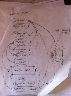
Typical spatial analysis of a larger sporting facility. With sporting facilities and maintaining high quality playing facilities there are major access issues with sporting shoes and casual shoes. The spatial diagram above resolves the issue but requires larger internal spaces where this design proposal is external with just a large cover.
This diagram indicates my intention with the sporting layout due to the space allowed for the sports. It was a first go at the spatial layout in a masterplanning scale. When presenting this i also displayed the rear connection along the cliffs and the cover i intend. This lacked a 3D aspect but showed my intention quite well.
Lastly i showed the section intent through the connections both visually and envionmentally of how a form like this can work.
All in all i think i did a good job considering this is just a concept and got my point across with effective diagramming.


No comments:
Post a Comment